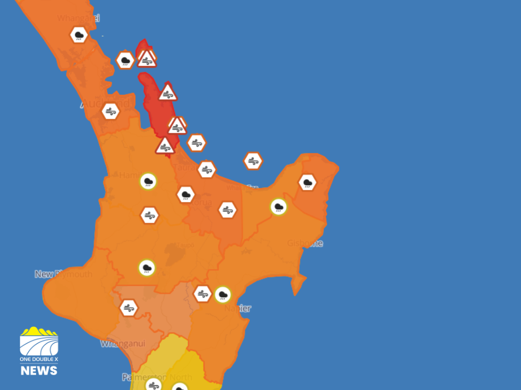
Category 2 tropical Cyclone Vaianu is set to hit land on Sunday, April 12, bringing strong winds and heavy rain to the North Island.
A heavy rain watch has been issued for the Bay of Plenty, about and east of Whakatāne, from 6:00am to 9:00pm on April 12.
MetService say there is a moderate chance of upgrading to a warning.
An orange heavy rain warning has been issued for the rest of the Bay, west of Whakatāne, from 2:00am to 4:00pm on Sunday.
MetService said to expect 150mm to 180mm of rain to accumulate, especially about the ranges.
"Peak intensities of 20 to 30 mm/hr Sunday morning and early afternoon," it said.
"In addition to the wind and rain, large swells and coastal inundation are likely."
There is a moderate chance of upgrading to a red warning.
A orange strong wind warning is in place for the Bay of Plenty and Rotorua from 4:00am until 7:00pm on Sunday.
"Severe gale easterlies changing to severe gale westerly Sunday afternoon, gusting 130km/h in exposed places," it said.
"High chance of upgrading to a Red Warning."
It said to expect power outages.
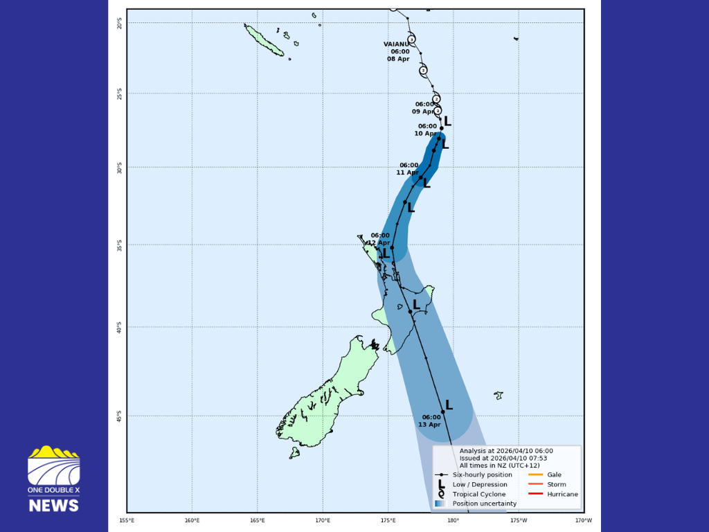
The latest forecast track map issued by Tropical Cyclone Warning Centre. IMAGE // MetService
Meteorologist Alanna Burrows said they are concerned about the weather that is on its way, with “extremely strong winds that could be life-threatening, as well as torrential heavy rain widespread across the North Island and some large waves.”
“We could see streams and rivers rapidly rising, surface flooding, slips and difficult driving conditions,” she said.
“There could be severe gales in exposed places… gusting over 110 kilometres an hour. This could cause damage to trees and power lines and might make driving very difficult.”
Burrows said large waves are expected, so “take that into consideration when you're thinking about your plans on Sunday.”
She said they are asking people to stay alert.
“We want people to be prepared and also be ready to change plans and be ready to have things at home, stock up and be prepared for this event coming,” she said.
“In terms of wind, we will say securing loose items in the garden, like trampolines. For heavy rain, you can clear gutters and adjust travel plans if necessary. Check in with neighbours, family, and friends to make sure they've got everything they need.”
Burrows said strong winds may cause disruption to powerlines, so have “some torches and batteries and have an emergency kit ready at home, just in case you need it.”
MetService said servere weather impacts could include road closures, fallen trees and power outages
MetService said orange wind watches could cause road closures.
NZTA have pre-emptively shut the Waioweka Gorge and parts of State Highway 35 for Sunday.
Whakatāne District Council said there is a high likelyhood coastal areas of Ōhope, including West End, will need to be evacuated tomorrow.
Friday, 10 April 16:00 UPDATE Whakatāne District Council said residents should prepare for possible evacuations in ŌHOPE.
Whakatāne District Council said there is a high likelyhood coastal areas of Ōhope, including West End, will need to be evacuated tomorrow.
Although evacuation orders are not currenlty in place, it said residents are being encouraged to prepare now.
Residents should plan where to go and pack essential items in a grab bag.
If evacuation is required, Police will door-knock all affected properties with clear information and next steps.
West End residents would have until 5pm Saturday to re-locate and a road block would be in place following this until daylight Monday.
Other coastal properties are encouraged to think about self evacuation and preparation also.
It said other areas of concern include beachfront properties along Pōhutuawa Avenue, Waterford Estate, Plantation Reserve, and low-lying properties bordering Ōhiwa Harbour such as Liddon Cover and Ōhiwa Parade.
Properties near cliffs or esccarpments are advised to self-evacuate to less risky locations.
Council warn there is a high likelyhood a Local State of Emergency will be declared tomorrow morning, which would allow teams to close areas, evacuate people and get resources to repsond to the event.
It said this is to ensure Council staff can take decisive action to keep people safe.
In the event of a Local State of Emergency and mandatory evacuations, an Emergency Evacuation Centre will open at the Whakatāne War Memorial Hall.
It said in any emergency situations move to somewhere less dangerous and if there is a threat to life call 111.
Friday, 10 April 15:45 UPDATE Bay of Plenty Regionl Council update.
The Bay of Plenty Regional Council has pre-emptively closed the Onekawa Te Mawhai Regional park on Sunday and said it will remain closed until it has been assessed as safe to open.
It said the Operations Team are also checking stopbanks, floodgates, drains and pumpstation ahead of the weather and will continue to monitor and respond to the impact of Cyclone Vaianu.
Boaties are urged to stay off the water or stay in moorings during the event, and should call the Duty Harbourmaster on 0800 5KNOTS (0800 55 66 87) to report incidents.
Before the weather, all mooring and vessels should be checked if it is safe to do so, it said.
The Bay of Plenty Harbourmaster will be closing the Whakatāne River bar from sunset Saturday until sunrise Monday.
Baybus services are currently operating as usual, but some services may be affected during the event.
Friday, 10 April 15:15 UPDATE Kawerau District Council urge preparation as it closes all Council facilities on Sunday.
Kawerau District Council has pre-emptively closed all Council facilities on Sunday.
This includes the Transfer Station, isite, the Maurie Kjar Aquatic Centre and no permits will be issued for Tarawera falls the entire weekend.
Council said residents will need to prepare prior to the event by bringing inside or tying down anything that could be impacted by the winds.
It urges people to make and practise an emergency plan, as well as having grab bags and emergency supplies ready.
"Be prepared with torches and have a solar or battery powered radio so you can keep up with the latest news and alerts."
It warns people to avoid travel or to arrive earlier in the day, and to stay inside where possible.
"Strong winds can fell trees and poles, tear off roofs, and cause branches and debris to fly at high speed."
It warns residents to be aware of the risk of flood waters and landslides.
Council said entering and kind of flood water on foot or in a car is extremely dangerous.
"Even water just 15 centimetres deep can sweep you off your feet, and half a metre of water will carry away most vehicles."
It said the Council team will be on stand-by over the weekend, but will need to assess if it is safe to respond during the height of the storm.
Reports can be made to the council's 24/7 call centre 07 306 9009.
Friday, 10 April 15:00 UPDATE Bay of Plenty Regional Council warns boats out level will be reached on Monday morning.
The Council Flood Team are forecasting the Whakatāne River will reach the first warning and Boats Out level in the early hours of Monday morning.
It said maximum wave heights are expected at noon on Sunday, but this could be subject to change.
An update on the conditions at the Whakatāne River mouth is expected at midday on Saturday.
Friday, 10 April 14:37 UPDATE NZTA urges motorists to reconsider travel during the worst of the weather.
NZTA said crews have been preparing for the potential impact of Cyclone Vaianu with road closures across state highways.
It said motorists should use this time to prepare and reconsider travel on Sunday.
NZTA is monitoring the forecast, and carrying out proactive maintenance such as clearing drains and culverts to minimise flooding impacts.
NZTA Regional Manager Maintenance Waikato and Bay of Plenty, Roger Brady said “A number of areas across the Waikato and Bay of Plenty have already been impacted by severe weather in recent months."
"In some locations, recovery works are ongoing and parts of the network remain fragile or vulnerable to further impacts."
It warns multiple sites are particularly prone to flooding in the Eastern Bay.
Sites of concern include State Highway 2 Matatā, the Ōtamarākau and Waimana Gorges, and State Highway 35 Toatoa to Pōtaka.
State Highway 30 between Kawerau Road to Matahi Road, as well as State Highway 30 West Nicholson Road to State Highway 1 are also prone to flooding.
NZTA advise following the precautions below during the weather event:
- Avoid non-essential travel during periods of heavy rain, strong winds and low visibility.
- If you must travel, drive to the conditions, keep your lights on, increase following distances and watch for surface flooding and debris.
- Never drive through flood water. It can be deeper or faster than it looks, and the road surface may be damaged underneath.
- Expect short-notice road closures, detours and delays. Obey all road closure signs and instructions.
- Check the latest state highway conditions on the NZTA Journey Planner before you leave, and during your trip if conditions change.
- Follow updates on Facebook for real-time updates.
Friday, 10 April 14:05 UPDATE Ōpōtiki New World warning of potential closure on Sunday.
The supermarket said due to staff and customer safety, their team considering a delayed opening or potential closure on Sunday.
It is urging customers to take advantage of the fine weather to get prepared and buy essentials.
"Any decisions will be made with plenty of consideration for both safety and essential access to groceries."
It said it is warning customers to give them the opportunity to plan ahead.
Friday, 10 April 14:01 UPDATE Latest update from Earth Sciences New Zealand.
Earth Sciences New Zealand Meteorologist Chester Lamkin said Cyclone Vaiano has been “downgraded from a tropical cyclone to just a cyclone,” but stressed it will still bring “very impactful weather.”
Speaking alongside Lampkin, Meteorologist John Law says the situation is rapidly developing, noting “there is plenty happening as we head through the weekend, particularly this Sunday,” which he described as “our key day.”
The storm is expected to bring a combination of hazards, with officials calling it “a multi-hazard event” involving “the wind… the rain… [and] the swell.”
Coastal areas are likely to face large waves and dangerous sea conditions, while inland regions may experience heavy rainfall and strong, shifting winds.
“Sunday…looks to be a pretty nasty day for many people on the North Island,” Law said.
“You’ve got a day or two, be prepared. There is weather on its way,” Law warned.
Both Lampkin and Law recommend monitoring updates through official channels, including the MetService website and app, as conditions and warnings may change quickly.
Friday, 10 April 13:54 UPDATE Bay of Plenty Civil Defence team urging people to get prepared.
The Bay of Plenty Civil Defence team said if it is safe to do so, you can follow these steps to help you prepare for the windy and wet weather brought by Cyclone Vaianu:
- Tie down or put away any loose objects, such as outdoor furniture and trampolines, that can become airborne in strong winds.
- Clear leaves or debris that may block gutters or drains, if it is safe.
- There may be surface flooding with streams and rivers rising rapidly. Stay away from floodwaters and do not attempt to drive through them.
- Tropical cyclones can cause power outages and disrupt roads and water supplies. Ensure you have essential supplies for at least three days.
- Charge mobile phones and devices, and think ahead about how you’d manage if power or communications were disrupted.
- If you have stock, move farm animals to areas that are safe from flooding and high winds.
- Look after one another and check on your neighbours and anyone who might need your help.
- Be prepared with torches and have a solar or battery-powered radio so you can keep up with the latest information and alerts.
- It’s always a good idea to have an emergency grab bag with essential items ready to go.
- If you do not feel safe at home, consider staying with friends, family, or whānau if possible. Remember to take pets and essential items with you, including medications.
Friday, 10 April 13:52 UPDATE Bay of Plenty Harbourmaster recommends all vessels remain off the water.
Bay of Plenty Harbourmaster Jon Jon Peters said Cyclone Vaianu is forecast to bring “extremely dangerous, potential life-threatening conditions on the water with dangerous sea swells, high winds and storm surge.”
He is recommending that all vessels remain off the water or safely on their moorings in the coming days.
“All mooring and vessel owners are advised to check their vessel and mooring well before the weather hits, but only if safe to do so.”
Friday, 10 April 13:38 UPDATE Whakatāne Bar to close.
Bay of Plenty Regional Council senior maritime officer for the eastern region, Dan Bramley, said the Harbourmaster will be closing the Whakatāne Bar from sunset (5:51pm) Saturday until Sunrise (6:36am) Monday.
He said this may be extended due to the uncertainty of the cyclones track.
"Coastguard will be broadcasting a Nav warning to this effect and the Bar Closed light will also be activated throughout this period," said Bramley.
"Please follow the advice of Civil Defence Emergency Management during this event, and if there are any issues please call 0800 55 66 87 and let us know."
Friday, 10 April 13:20 UPDATE Kawerau District Council urging residents to get prepared, and pre-emptively close Maurie Kjar Aquatic Centre on Sunday.
Kawerau district Council are warning residents to prepare prior to the storm, and stay safe on the roads.
It encourages residents to reduce travel where possible, but said those who do drive on Sunday will need to drive to the conditions and check the NZTA journey planner for road closures.
It said the Council team will be on stand-by over the weekend, but will need to assess if it is safe to respond during the height of the storm.
The Maurie Kjar Aquatic Centre will be closed on Sunday 12 April, and Council said other facilities may need to be closed closer to the time.
Reports can be made to the council's 24/7 call centre 07 306 9009.
Friday, 10 April 12:00 UPDATE Ōpōtiki District Council encouraging residents to prepare ahead of Cyclone Vaianu
Ōpōtiki District Council are urging residents to ensure they have done what they can "to prepare for potential winds and heavy rain."
Civil Defence Controller Antoinette Campbell said the council are doing what it can to ensure itself and the community are prepared for the upcoming weather.
"We are closely monitoring weather forecasts for Cyclone Vaianu and assessing possible implications for, particularly, our more remote coastal communities."
She said households should make plans for livestock, move or secure things that will get blown about by winds, change travel plans, check gutters are clear, and stay up to date with the latest weather information.
"Preparing early helps avoid rushed decisions later and while no evacuations are required at this stage, if residents are concerned because they live in low lying coastal areas then they should think about moving inland to stay with friends and whānau now, before the cyclone arrives on Sunday morning," said Campbell.
"Having an emergency grab bag ready is another early preparation measure that families can do now. It includes things like torches, batteries, chargers, medication, non-perishable food and drinking water - the things you know your whānau will need in an emergency."
Thursday, 9 April 15:37 UPDATE Whakatāne River condition.
The Whakatāne River has past it's peak and is dropping.
Bay of Plenty Regional Council senior maritime officer for the eastern region, Dan Bramley, said the catchment is already soaked from this week’s rain and “it will not take much for the river to reach warning levels again on Sunday.”
“The BoPRC Flood, Harbourmaster and Emergency Management Teams are monitoring the situation.”
Thursday, 9 April 13:51 UPDATE Whakatāne District Council urge residents to be prepared.
Whakatāne District Council are urging residents to prepare early as Cyclone Vaianu nears.
The council are closely monitoring the storm, set to begin impacting parts of Aotearoa New Zealand from early Sunday morning.
Council said emergency response planning has been activated, "with the Council working alongside MetService New Zealand and partner agencies to track the system and prepare for potential impacts."
Local controller Nicholas Woodley says there is uncertainty around the cyclone's exact path; however, the message to prepare now remains clear.
“This is a system we are taking very seriously,” said Woodley.
“While we can’t yet say exactly what impacts we will see locally, there is enough uncertainty and potential risk - particularly around coastal surge and heavy rainfall - that people should be preparing now rather than waiting.”
Council are already responding to the effects of the last system of heavy rain, "including surface flooding, downed trees and localised road issues."
"With ground conditions saturated, the risk of slips and landslides is heightened, especially in steep or vulnerable areas," it said.
Woodley said now is the time to prepare because "we know how quickly weather impacts can escalate in this district.”
“Preparing early - securing loose items, planning for possible power outages, and thinking about what you would do if access became limited - helps avoid rushed decisions later.”
No evacuations are required yet, but Woodley said the council are encouraging residents, particularly in coastal areas, or those who feel unsafe, to make early arrangements to stay with friends and whānau.
“Cyclone conditions are currently forecast to arrive around 3am Sunday. No one wants to be evacuating in the dark, in severe weather,” he said.
“If you have concerns about your safety, the safest option is to move early - ideally before Saturday night - and stay with friends or whānau.”
If evacuations become necessary, they will be led by the police, with affected properties door-knocked directly.
Council urges people to stay well clear of beaches, river mouths and coastal areas, "where conditions can become unpredictable very quickly."
A Welfare Centre will be activated at the Whakatāne War Memorial Hall and potentially at other locations if required.
Residents who notice flooding, slips, fallen trees or road damage should report them to the council.
Urgent issues can be reported to the council's 24/7 call centre on 07 306 0500, and no urgent issues should be logged using the Fix It and Report a Problem form on the council's website.
“Our priority is keeping our communities safe and well-informed. Prepared beats panicked. This is about being ready, not being alarmed,” said Woodley.
Thursday, 9 April 11:24 UPDATE Keeping your animals safe.
The Ministry of Primary Industries are advising communities to include animals in emergency planning.
Pets should be easy to identify with things such as ID tags and microchips, in case you get separated from them.
For livestock, MPI said large animals such as horses should have a tag added to their halter, lead or cover and be microchipped.
"Ensure your National Animal Identification and Tracing (NAIT) programme details are up-to-date."
It said you should ensure you have emergency kits for both yourself and animals, including things like first aid kits, food and water.
Thursday, 9 April 08:33 UPDATE Boil notice for Rūātoki.
A boil notice is in place for Rūātoki residents.
The council said the recent heavy rain means the Rūātoki Water Treatment Plant isn’t working properly.
“The water is dirty and cloudy (high turbidity), which means the UV system may not be removing all the bugs from the water.”
Residents should boil water for at least 3 minutes before using it for drinking, cooking, brushing teeth, or preparing food.
“If you're using an electric jug, you may need to boil it twice to reach 3 minutes,” said the council.
“This notice is a precaution and will stay in place until the water is confirmed safe to drink.”
Council is testing daily.
 Coastal Residents Urged to Prepare for Potential Evacuations Tomorrow
 Bad Weather Causing Flooding and Pre-Emptive Closures Across the Region
 Scheduled Maintenance for Pekatahi Bridge Cancelled
 Air Chathams Cuts Whakatāne Flights by 45 Percent Amid Fuel Cost Surge