The Bay of Plenty west of Whakatāne is under a heavy rain warning until 1am Saturday morning.
MetService said the region can expect another 70 to 100mm of rain on top of what has already fallen, with peak rates of 15 to 25 mm/h.
Throughout Friday, peak rates of 25 to 40 mm/h are possible.
There is a high chance of upgrading to a red warning.
MetService warns that dangerous river conditions, flooding, and slips are likely.
It said driving may become unsafe, and motorists should expect road closures.
“Do not enter floodwaters, and avoid unnecessary travel. Be ready for communication and power outages. Be prepared to self-evacuate if you see rising water.”
The Bay of Plenty, north of Te Kaha to Gisborne, north of Tokomaru Bay, is under a heavy rain watch from 3am Friday until 12pm Saturday.
There is a moderate chance of upgrading to a warning.
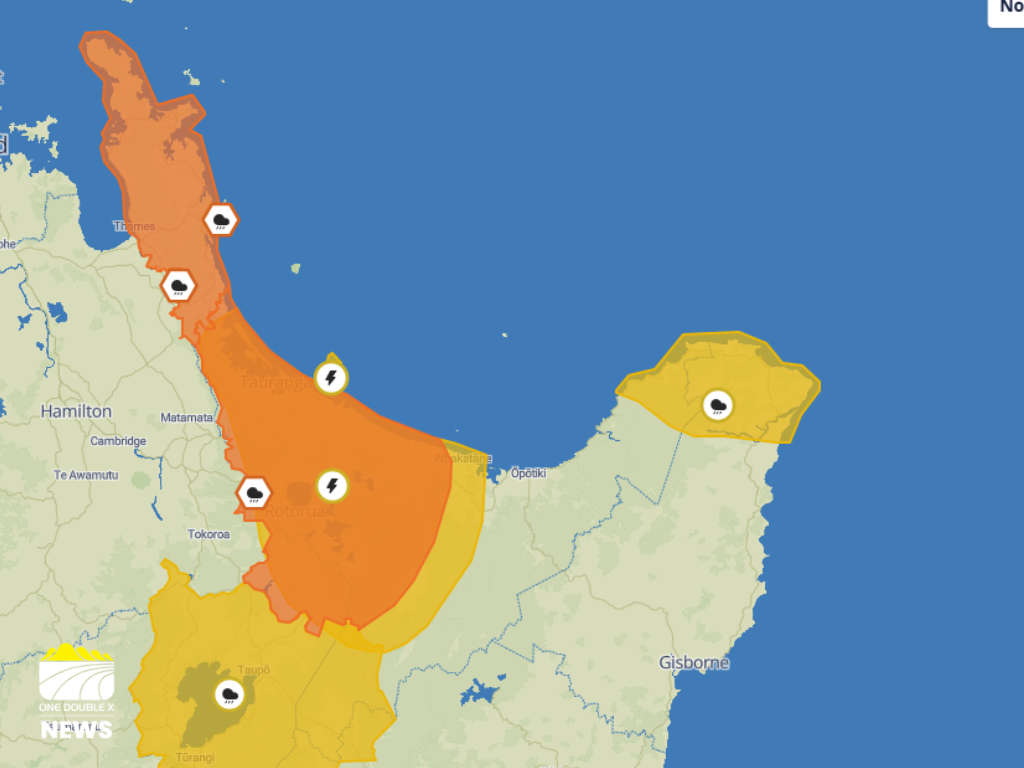
There is a moderate chance of localised downpours throughout the Bay of Plenty. IMAGE / MetService
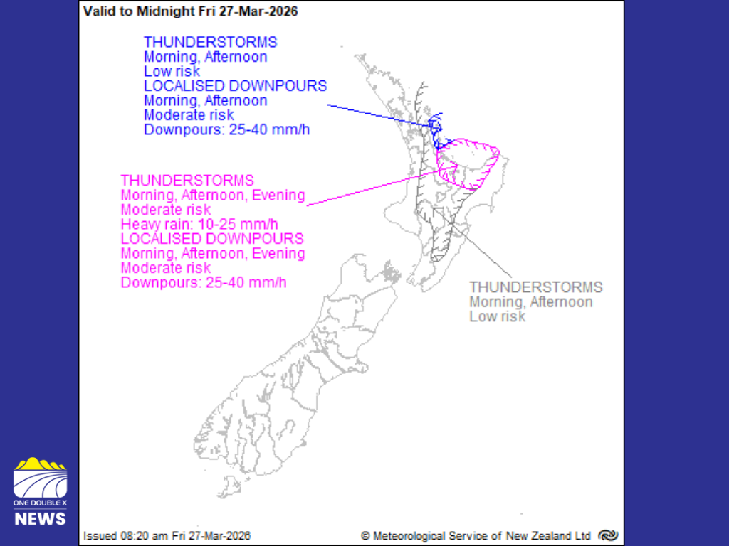
A severe thunderstorm warning is in place for the Bay of Plenty, and Rotorua from 8.34am to 12.00pm today.
MetService said an active front is bringing periods of heavy rain and a few thunderstorms.
"There is a moderate risk of localised downpours of 25 to 40 mm/h in western and central Bay of Plenty this morning."
It said downpours can occur withour thunderstorms.
Thunderstorms are expected to hit between 7.45am and 8.15pm. IMAGE / MetService
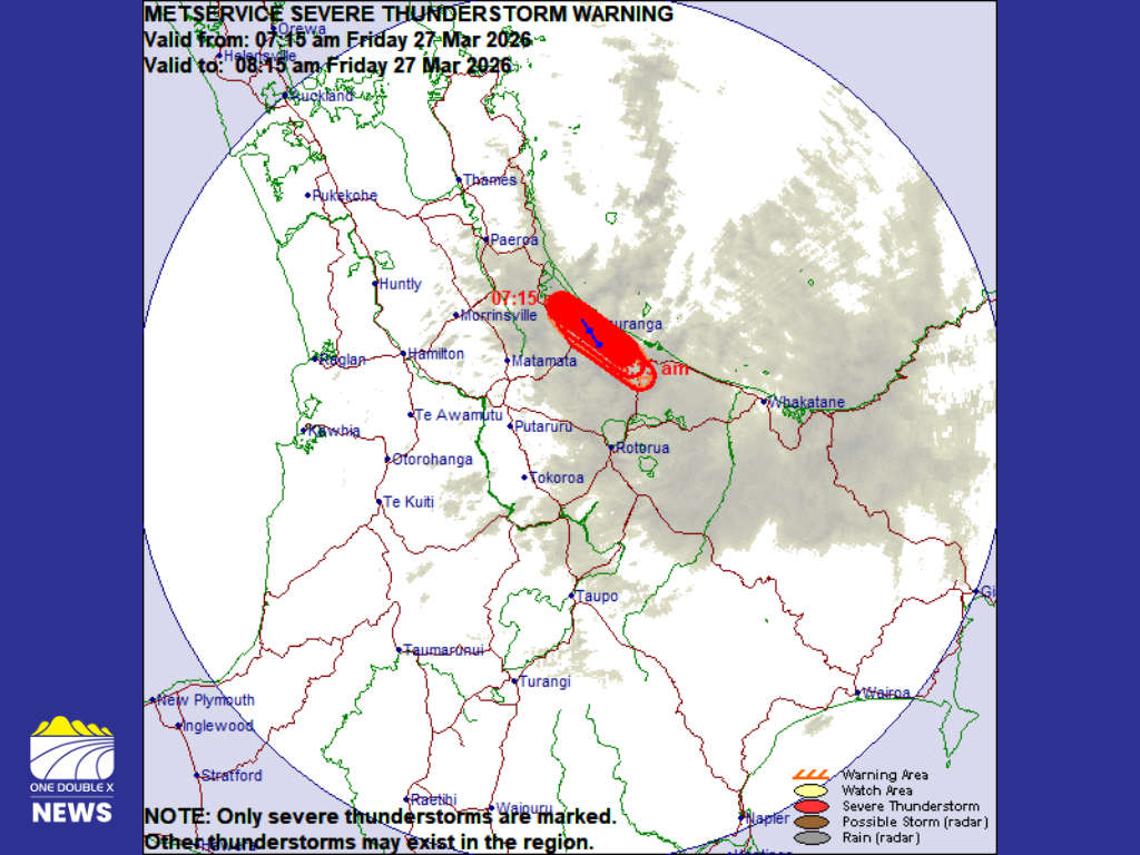
The severe thunderstorm warning has been lifted for the Western Bay of Plenty and Tauranga.
MetService said their weather radar has detected a line of thunderstorms lying from Matakana Island to Tauranga to Te Puke.
"This line of severe thunderstorms is moving towards the southeast, and is expected to lie from Omokoroa to Tauranga to Te Puke at 7.45 am and from Te Pune to Tauranga to Paengaroa at 8.15 am," it said.
These thunderstorms are expected to be accompanied by very heavy rain.
"Very heavy rain can cause surface and/or flash flooding about streams, gullies and urban areas, and make driving conditions extremely hazardous."
Meteorologist John Law said a deep area of low pressure has brought warmth, moist and windy conditions down from the tropics.
"The winds rotate in a clockwise fashion. So you can imagine that with that out towards the west of us, those are northerly winds just pushing that rain down," he explained.
"Places like the Bay of Plenty and the Coromandel act a bit like a funnel, but those northerly winds just catching that rain, pushing it towards the northern ranges down towards the south [of the area]."
Law advises the community to keep an eye on the forecasts with a high chance of the warnings being upgraded.
"Keep up to date with the latest forecasts, watches, warnings over on the MetService website and also with the information from your local emergency management teams on the ground as well."
Bay of Plenty Civil Defence is warning people to be prepared as the weather sets in.
It is advising anyone with planned outdoor activities to postpone and to avoid travel where possible.
"The rainfall forecast is still likely to bring dangerous river conditions, flooding, hazardous driving conditions, and landslides, so please take care," it said.
If floodwaters rapidly rise, "do not wait for official warnings - head for higher ground and stay away from floodwater."
It warns there will be slippery roads, as well as potential landslides and fallen trees.
Early signs of landslides include "small slips, rock falls, new cracks or bulges on the ground, tilting trees, fences, and fixtures, water flowing out of a slope, sticking window frames and doors, and unusual noises."
"If you see any of these, act quickly, get away from the slope and call 111."
It is also urging people to be prepared for power outages and communication network disruptions.
NZTA has warned motorists to be prepared for road closures throughout the warning period.
It said while the alert is in place for west of Whakatāne, conditions may change quickly.
It warns that closures could be expected if the weather worsens.
"State Highway 2 through the Waioweka Gorge may be closed at short notice if conditions deteriorate and it becomes unsafe for travel."
It said the situation will be assessed as the forecast is updated.
NZTA encourages motorists to check for updates, allow for extra travel time, and prepare to use alternative routes.
Community Constable Rob Jones said drivers will need to increase their following distance, turn on lights, and avoid travel if possible.
Whakatāne Mayor Nándor Tánczos said Herepuru Road will be closed from 12pm Thursday, as a precaution.
He said the last period of heavy rain caused a large slip; therefore, closing the road is the safest option.
Affected residents have been notified.
 Single Vehicle Crash Near Edgecumbe
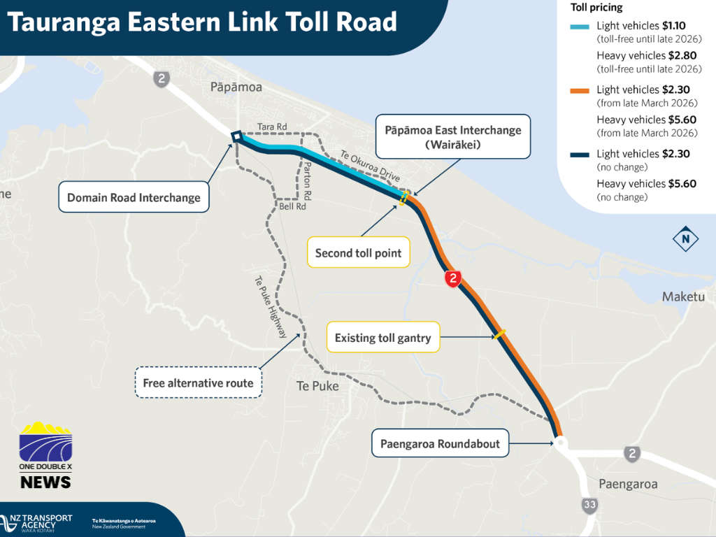 Second Toll Point to be Installed on Tauranga Eastern Link Toll Road
 Fear Wild Dogs Pose Threat to the Bird and Human Life
 Bay of Plenty Councils Explore Shared Water Services Option