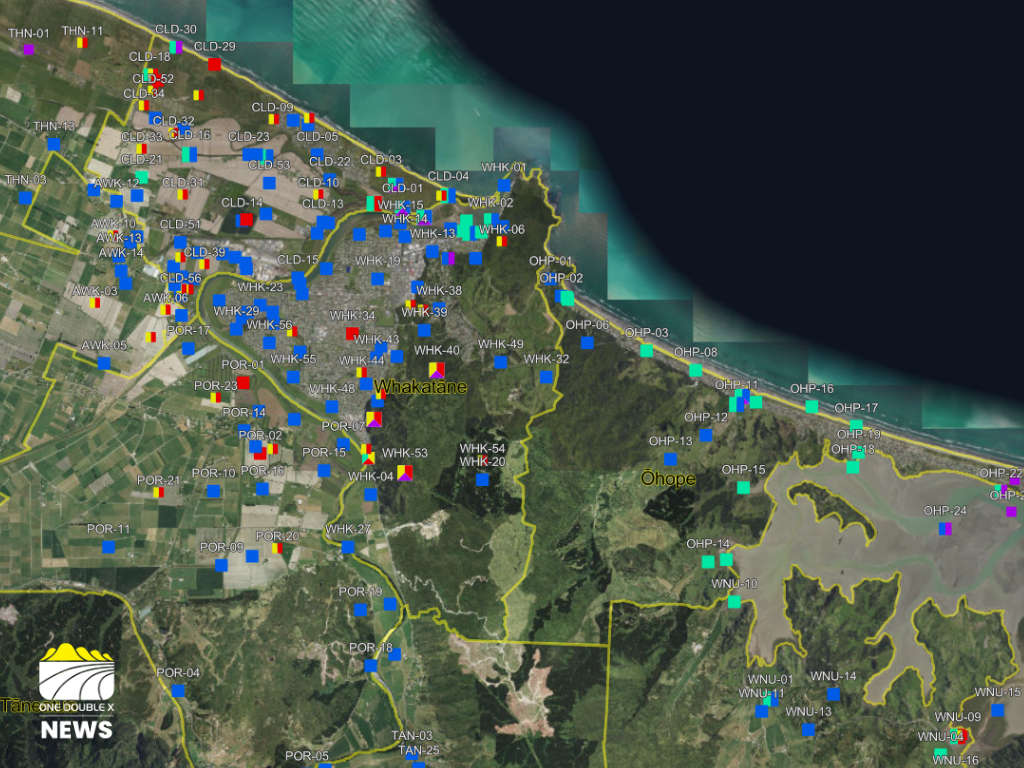
An interactive online map has been launched to help communities in the Whakatāne District better understand how climate change could affect where they live.
The Whakatāne District Council released the tool, called Adaptation Explorer, on Friday.
It allows users to enter an address and explore broad areas that may be exposed to hazards such as flooding, landslides, coastal erosion, sea-level rise, and extreme heat.
The council says the tool is designed to support awareness and early planning, rather than provide property-specific assessments.
Climate Change and Resilience Manager Lou Hunt said the impacts of climate change were already being felt across the district.
“Climate change isn’t something we’re expecting to happen one day; it’s already affecting parts of our district,” she said.
Hunt said the tool aimed to make complex information easier to understand and discuss.
Adaptation Explorer was developed as part of the council’s wider climate adaptation programme, based on a district-wide risk assessment completed in 2025.
That work involved input from more than 800 people, including iwi, hapū, community groups, and technical experts.
The mapping highlights general hazard areas and incorporates risks observed by communities, but does not assess individual homes or buildings.
Hunt said it was important people understood the limitations.
“It’s a guide to help start conversations and ask the right questions,” she said.
The council said making the information publicly available would help residents, businesses, and planners make more informed decisions as climate risks increase, including more frequent storms, flooding, and hotter, drier conditions.
It also noted that property-level risk can vary depending on factors such as building design, site conditions, and mitigation measures, and may require professional advice.
The tool will be updated as new data becomes available.
“This isn’t a one-off piece of work,” Hunt said.
“The data will continue to be updated as we learn more and as conditions change.”
The council is also hosting a series of drop-in sessions at its chambers later this month and in April to help residents learn how to use the tool.
 Community Reference Group for Awakeri Development Opens
 Recent Water Mains Breaks Caused by Faults
 Community Invited to Shape Future of Whakatāne Riverfront