Earth Sciences New Zealand warns of growing dryness concerns across the Eastern Bay of Plenty, with warmer temperatures and fewer widespread rain events expected over the coming months.
The Eastern Bay of Plenty is heading towards a drier-than-usual summer, with very strong El Niño conditions expected to influence New Zealand’s weather through to January.
Earth Sciences New Zealand (ESNZ) meteorologist Chester Lampkin said the November 2026 to January 2027 outlook pointed towards reduced rainfall across the eastern North Island, although occasional wet periods remained possible.
“We’re in the opposite of last year,” he said, referring to the particularly wet summer experienced across the Bay of Plenty.
The latest seasonal outlook, issued on 29 October, forecast below-normal rainfall and soil moisture across the north and east of the North Island.
For the wider Bay of Plenty, the outlook gave a 45 per cent chance of below-normal rainfall and soil moisture, and a 45 per cent chance of below-normal river flows.
Temperatures were also expected to be above average, with a 50 per cent chance of warmer-than-usual conditions across the region.
Lampkin said the Eastern Bay was already experiencing dry conditions, with the outlook suggesting that dryness could become a growing concern for agriculture and other water-dependent industries.
However, residents should not expect the region to remain completely rain-free.
“We’re actually coming into a wetter period right now,” he said.
Warmer, more humid conditions were expected to continue into November, with occasional rain possible despite the overall seasonal pattern favouring drier weather.
The outlook covered three months as a whole, meaning individual wet and dry spells would still occur.
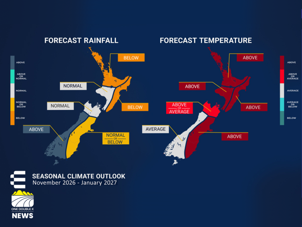 For the Eastern Bay of Plenty, ESNZ is forcasting below normal rainfall and above average temperatures over the coming months. IMAGE // ESNZ
The latest climate outlook described very strong El Niño conditions across the tropical Pacific, with the event expected to strengthen further and potentially reach its peak between November and January.
Lampkin said the developing event was tracking as expected and could become one of the strongest El Niño events in modern records.
The official outlook said oceanic indicators had already exceeded some historical El Niño peaks, with the event potentially becoming the strongest observed in the instrumental era.
El Niño was expected to influence atmospheric circulation across New Zealand, favouring westerly and southwesterly weather patterns.
For the eastern North Island, this typically meant less rainfall overall, although individual weather systems could still bring significant rain.
Lampkin said the region might still experience occasional moisture from systems developing north of New Zealand.
The outlook also identified the possibility of tropical cyclones moving south into the region during summer.
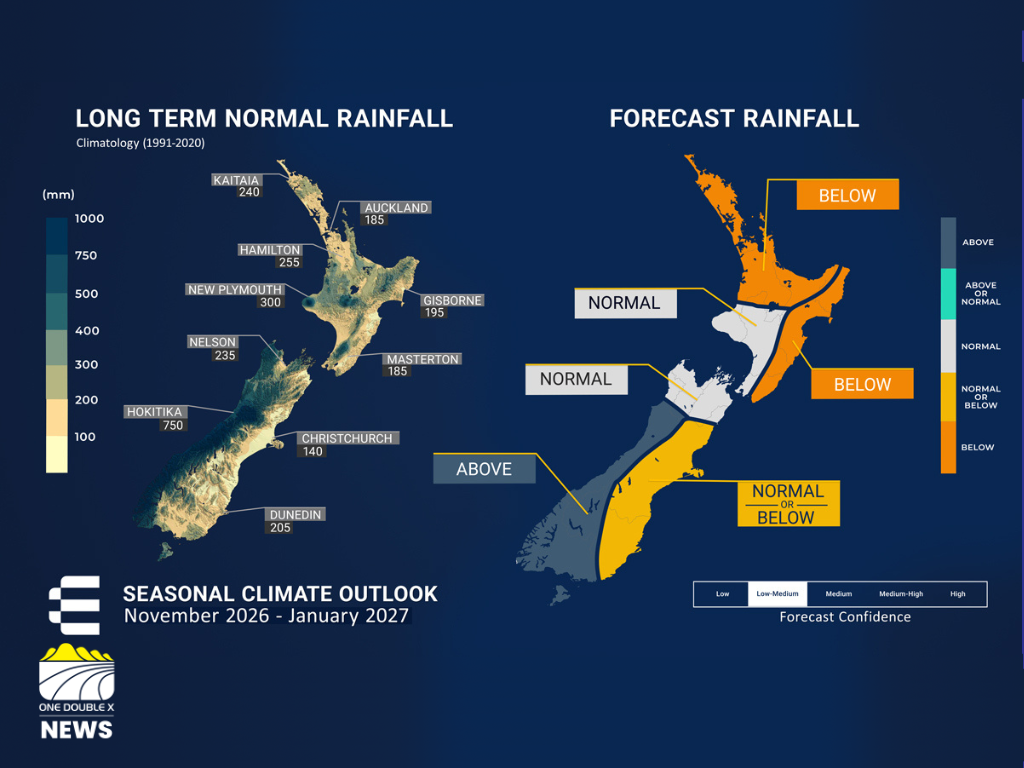 The long term average rainfall across Aotearoa compared with the forecast average for the next three months. IMAGE // ESNZ
While the overall outlook favoured fewer heavy and widespread rainfall events, Lampkin said the possibility of an ex-tropical cyclone could not be ruled out.
An ex-tropical cyclone, sometimes referred to as an XTC, is a former tropical cyclone that has moved out of the tropics and lost its tropical characteristics.
These systems can still bring significant moisture and rainfall to New Zealand.
Lampkin said the Bay of Plenty experienced the effects of ex-tropical cyclone Banu last summer, which contributed to the region’s wet conditions.
He expected the possibility of an ex-tropical cyclone to remain part of the summer weather picture, although its eventual path was difficult to predict.
A system could move towards Northland, affect another part of the North Island or miss New Zealand entirely.
The seasonal outlook also noted that tropical cyclone activity across the Southwest Pacific was forecast to be normal to above normal overall, although the risk for northern New Zealand was considered near normal.
A drier summer could be welcomed by people planning beach trips, camping, hiking and outdoor activities.
However, Lampkin said the same conditions could create challenges for farmers, horticulture and other industries that depended on reliable water supplies.
With reduced rainfall expected across the Eastern Bay, soil moisture and river flows could decline further.
The seasonal outlook warned that below-normal soil moisture and river flows were already evident across parts of the North Island, with continued drying expected in the east and north.
Residents and businesses that relied on water were encouraged to keep the changing conditions in mind as summer approached.
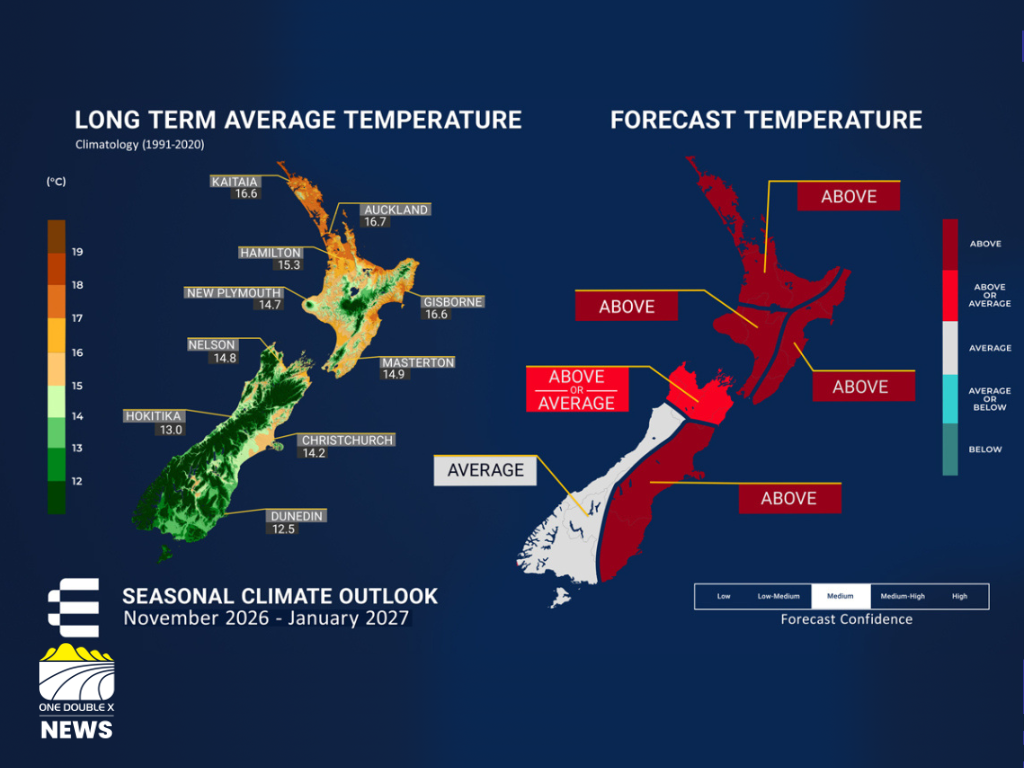 The long term average temperatures across Aotearoa compared with the forecast average for the next three months. IMAGE // ESNZ
Lampkin also warned of the importance of sun protection as warmer weather arrived, epxlaining that sunscreen was important for everyone.
He highlighted the importance of taking care in the strong New Zealand sunshine, particularly during periods of unusually high temperatures.
The seasonal outlook expected above-average temperatures to be most frequent and intense on the eastern sides of both islands.
Lampkin said the developing climate conditions offered opportunities for outdoor activities, but residents should remain aware of the risks associated with heat, dryness and strong sunshine.
The key message for the coming three months was that the Eastern Bay of Plenty was likely to experience warmer and drier-than-normal conditions, with occasional rain but fewer widespread heavy rainfall events than last summer.
The outlook was not a prediction of exactly what would happen on any individual day.
Earth Sciences New Zealand said seasonal forecasts described the overall pattern expected across a three-month period, while individual weather events remained more difficult to predict.
Residents were encouraged to continue checking short-term weather forecasts as summer approached, particularly when planning outdoor activities or managing water-dependent work.
The latest seasonal outlook covered November 2026 to January 2027, with Earth Sciences New Zealand continuing to monitor the developing El Niño event and its potential impacts on New Zealand’s climate.
 Whakatāne Considers $20 Million to $59 Million Investment Options for Rex Morpeth Hub
 Traffic Moves Onto New Twin Roundabouts Near Ōpōtiki
 Whakaari Eruption Ceases as Volcanic Alert Level Lowered
 Two Youths Arrested Following Edgecumbe Hammer Attack