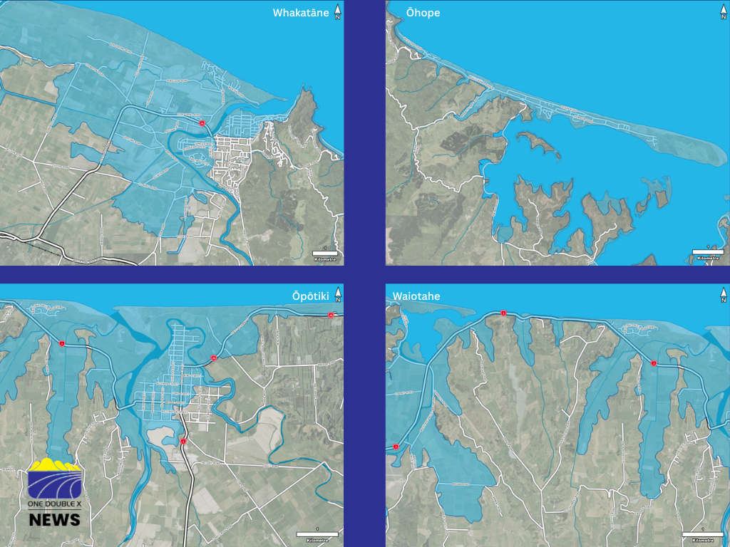
New tsunami evacuation maps are now available for people living, working and visiting coastal areas of the Bay of Plenty.
The updated maps show revised “blue zones”— areas that need to be evacuated in the event of a tsunami.
They are based on new computer modelling and data from Earth Sciences New Zealand, which predicts how far inland tsunami waves could travel depending on their size and source.
Bay of Plenty Regional Council and Emergency Management Bay of Plenty worked with local councils across the region to update the maps, taking into account factors such as evacuation routes, road networks, population density and safety considerations.
Bay of Plenty Civil Defence said the latest update means some areas have seen significant changes, while others have only minor adjustments.
“We encourage everyone to check the new evacuation maps to see if there have been changes in their area.”
The region moved to a single “blue zone” system in 2023, replacing the previous red, orange and yellow zones used for different tsunami scenarios.
The simplified system makes it “much easier to know who needed to evacuate and where to evacuate to.”
More than 150 tsunami evacuation signboards across coastal parts of the Bay of Plenty will begin to be updated from Monday, with digital versions of the maps already available online through Civil Defence and local council websites.
Emergency Management Bay of Plenty regional manager Jono Gracie said it was important for households to review the maps and include them in their evacuation planning.
“Any means of evacuation that does not contribute to traffic congestion should be considered, including walking or cycling if you can,” said Gracie.
The new maps serve as a reminder to the community to understand the signs of a tsunami.
Bay of Plenty Civil Defence said that in the case of a tsunami generated close to New Zealand’s coastline, there may be little or no time for official warnings.
“People are advised to follow the guidance: 'long or strong, get gone', meaning if an earthquake is long or strong enough to make it difficult to stand, they should evacuate immediately.”
Other natural warning signs include sudden changes in sea level or unusual ocean noises.
Knowing the signs and evacuating without delay remains the safest response.
 Bronze Plaque Stolen From Whakatāne Kiwi Trust’s Wandering Trail
 Whakatāne Waste Fees to Rise 10% as Council Confirms Annual Charges
 Victoria Cross Recipient Willie Apiata to Speak on Resilience and Wellbeing in Eastern Bay
 Whakatāne Riverfront Enhancement Moves Forward, Asbestos Removal Begins in July